Shortly after the two devastating earthquakes that struck Venezuela on Wednesday evening, the United States Geological Survey (USGS) released an estimate that caught the attention of the entire world: the final death toll could range between 10,000 and 100,000.
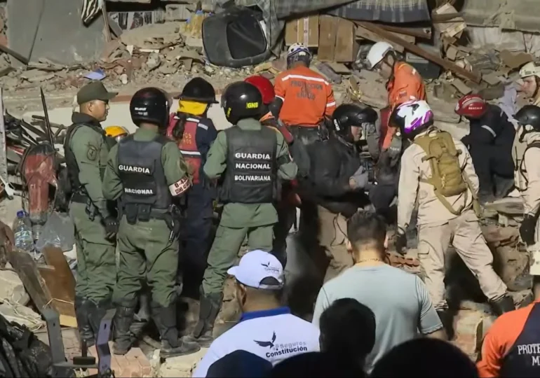
Over ten hours after the earthquakes occurred, Venezuelan authorities had reported a provisional toll of 32 dead and over 700 injured, even though they warned that the number of victims would increase as search and rescue operations continued.
However, the huge difference between the two figures has an explanation. The estimate published by USGS is not a forecast or a victim count, but the result of a statistical model designed to help authorities and response teams quickly understand how serious a disaster could become and mobilize the necessary resources, writes BBC.
What Is the PAGER System
The estimate is automatically generated by the PAGER system (Prompt Assessment of Global Earthquakes for Response), developed by the United States Geological Survey.
According to USGS, the system provides an initial assessment approximately 20 minutes after a strong earthquake occurs and is used for earthquakes with a magnitude of at least 5.5.
Its purpose is not to determine how many people have died, but to quickly provide intervention teams, governments, and international organizations with an overview of the likely impact of an earthquake before local authorities can assess the situation on the ground.
How USGS Calculates the Risk of Victims
The system does not estimate the possible number of victims solely based on the magnitude of the earthquake.
The model takes into account the earthquake's location, magnitude, and depth, the estimated intensity of ground shaking, the exposed population, the types of buildings and their vulnerability in the affected area, as well as the outcomes recorded in similar earthquakes that occurred in the past.
Based on this data, PAGER calculates the probability of different scenarios regarding human casualties and the extent of material damage.

Why Estimates Can Sometimes Appear Exaggerated
USGS emphasizes that PAGER estimates are preliminary and are updated as new information becomes available from the field.
The actual number of victims depends on numerous factors that cannot be immediately assessed, such as building resilience, compliance with seismic standards, the efficiency of rescue operations, or even the timing of the earthquake.
For example, an earthquake occurring at night when most people are asleep generally poses a higher risk of causing casualties than one happening during the day when evacuation is quicker.
PAGER Estimates Economic Damages as Well
The PAGER system does not only analyze the risk of human losses. It also estimates the economic impact of an earthquake.
Based on these assessments, USGS assigns one of the four alert levels – green, yellow, orange, or red. The final level is determined based on the scenario with the most severe impact, whether it involves human casualties or material damages.
Why Venezuela Received a Red Alert
In the case of the earthquakes that occurred in Venezuela on Wednesday, the PAGER system issued a red alert, the highest level of severity. According to USGS, this indicates that the earthquake has the potential to cause very high human casualties and extensive material damage, justifying the rapid mobilization of intervention resources.
BBC notes that globally, on average, only one or two such alerts are issued each year.
However, a red alert does not mean that the worst-case scenario will materialize. It serves as a warning about the potential severity of the event and can be revised as new field data emerges.
The Strongest Earthquake in Venezuela in Over 120 Years
According to USGS data, one of the two earthquakes that occurred on Wednesday is the strongest recorded in Venezuela since 1900.
The last comparable earthquake was the San Narciso earthquake, with a magnitude of 7.7, which occurred off the coast of Venezuela on October 29, 1900.
Experts explain that Venezuela is located in an active seismic zone, at the boundary between the Caribbean Plate and the South American Plate. The two earthquakes on Wednesday were generated by the movement of these tectonic plates, and USGS warns that further aftershocks are possible, some of them strong enough to cause additional damage.