

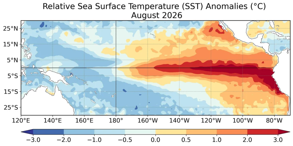
The El Niño climate phenomenon is rapidly intensifying and could become the strongest ever recorded. According to the World Meteorological Organization (WMO), it will peak in December and continue to influence the weather in the early months of next year, with unusually high temperatures, droughts, and floods in various regions of the world.
The probability of El Niño persisting until February 2027 is nearly 100%, according to estimates presented on Thursday by the UN agency.
The phenomenon manifests through the unusual warming of surface waters in the central and eastern Pacific Ocean, near the Equator. Although it occurs in a well-defined region, its effects are felt globally, as it alters atmospheric circulation and precipitation patterns.
A Possible Historic Record
The current El Niño episode began in June and intensified much faster than anticipated. In a region of the Pacific used by meteorologists to monitor the phenomenon, the water temperature was 1.6 degrees Celsius above normal in June. By August, the difference had already reached 2.5 degrees.
The WMO estimates that from October to December, the deviation could reach approximately 3.7 degrees Celsius, peaking in December.
If the forecast is confirmed, it would be the highest value recorded since the beginning of observations, surpassing by far the previous record of 2.6 degrees set during the 2015-2016 El Niño episode.
"The El Niño phenomenon is already well established and intensifying rapidly. According to the WMO forecasts, the probability of it persisting until February 2027 is close to 100%, which could make it one of the most intense episodes recorded at least since 1950," said Celeste Saulo, the organization's Secretary-General.
What It Means for Global Weather
A strong El Niño can alter the weather across entire continents. Some regions face higher temperatures and lack of precipitation, while others may experience heavy rains and floods.
The effects are already visible. In Central America, drought is affecting crops and livestock. In India, disrupted monsoons are endangering harvests.
However, risks vary from region to region, and El Niño does not automatically trigger the same meteorological phenomena everywhere.
In Europe, the influence of the El Niño phenomenon is less direct than in other regions of the world. Its effects on Romania's weather are hard to predict as they also depend on other climatic factors.
Why a New Extremely Hot Year Could Follow
The intensification of the phenomenon comes at a time when the planet is already experiencing very high temperatures amid climate change.
The WMO warns that El Niño can temporarily amplify global warming as it facilitates the transfer of heat accumulated in the ocean to the atmosphere. "El Niño does not bring additional warmth to the planet. It releases the heat the ocean has already stored below the surface," explained Celeste Saulo.
According to her, the issue is that the oceans are already warmer than ever during the observation period. "Simply put, there is more heat ready to be released," warned the WMO chief.
For this reason, strong El Niño episodes are often associated with some of the warmest years in history.
The current forecast by the WMO is based on data collected by satellites, ocean buoys, and meteorological instruments, analyzed by 13 national and international specialized centers.