
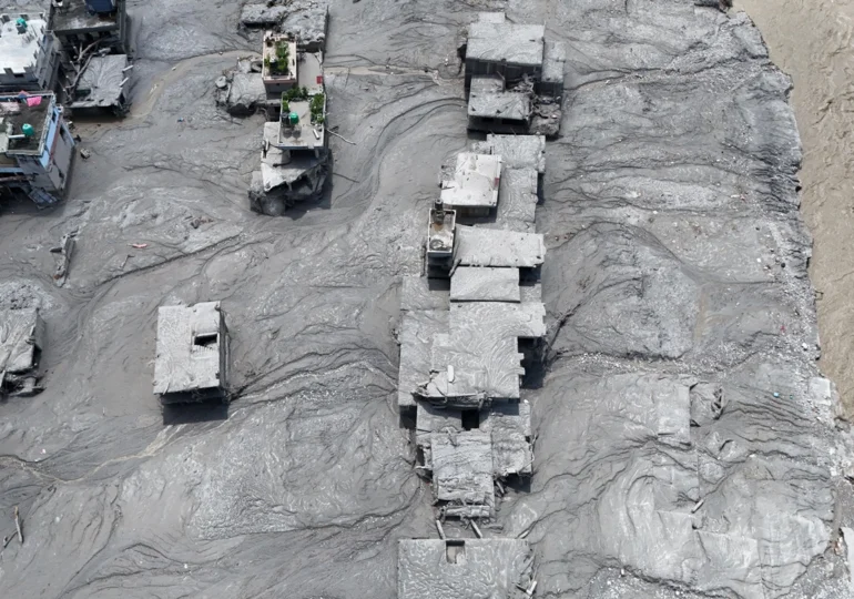
The collapse of a glacier in the Himalayas has created a devastating wave of water, mud, and debris that swept through a valley in Nepal, leaving behind hundreds dead and hundreds more missing. How was this catastrophe possible?
Stuart Dunning, a professor of applied geomorphology, studies disaster risk reduction in high mountain areas and has closely analyzed the 2021 Chamoli disaster, a similar event to the one in Nepal. He is part of an informal group of over 50 international experts who pool their knowledge to provide rapid analyses of such events.
Dunning explained to The Conversation the scientific aspects of this event, also shedding light on what we can expect in the future.
Three hypotheses for the Nepal disaster
Experts are still trying to decipher the exact sequence of events that led to such a large amount of debris and water downstream. There are several hypotheses, as Dunning points out:
- a massive land landslide (from bedrock) dragged the glacier with it.
- a rock landslide destabilized the glacier, which then collapsed shortly after.
- the glacier collapsed first, subsequently dragging down the rock above.
The best description of the disaster is that of a mixed rock and ice avalanche, triggered at an altitude of about 4,800 meters, which descended over a vertical drop of over 1,200 meters, the professor believes.
Sequence of events
The amount of ice involved in the initial collapse - likely supplemented by subsequently entrained ice - was sufficient to generate the water needed to transform the mass into a devastating flow of debris, with a wide propagation radius. Such a phenomenon is much more destructive than a dry rock avalanche.
The flow moved along the river course, accumulating water. Along the way, it eroded both the valley bottom and its slopes. The accumulated material was deposited downstream, Dunning explains.
What happened there is hard to describe. Even experts do not know how to classify this event - a catastrophic flood caused by the outburst of a glacial lake, a landslide, an ice avalanche. The group of over 50 experts in natural hazards, including Stuart Dunning, is still debating how this phenomenon should be named.
It is easy to understand why initial reports assumed it was a flood caused by the outburst of a glacial lake (known by the acronym GLOF), as this is probably the most well-known source of such cascades of phenomena. However, in this case, there was no lake.
For now, the professor calls the entire event a cascade of risks or a chain of processes. It all started with a landslide that entrained uncertain volumes of rock and ice. Most of the ice melted due to fragmentation and the heat generated by friction. "In other similar cases, we have found in deposits rounded ice fragments that were transported during the event and only melted later," he said.
Why was this disaster so deadly
Events turn into disasters when they exceed our capacity to cope with them. Few things could withstand such a fast-moving wave of mud, rocks, and water. Everything on the valley floor or the lower slopes, as the mass of materials spilled down the bends of the path, was at risk.
Rock avalanches frequently occur above glaciers in Alaska. Some travel several kilometers. The difference is that these do not fully transform into a fluid mass, and human settlements are not immediately downstream. In the Himalayas, abrupt and retreating glaciers are not far from communities.
What satellite images can tell us
Satellite data is often updated daily, allowing for the identification of secondary risks, such as water accumulation behind debris blockages, which could trigger new flash floods, or the presence of large masses of unstable-looking materials.
The combination of ground-based data (photographs, video recordings) and seismic data allows for measuring the speed of movement, depth, and water content of the phenomenon. These pieces of information are then cross-referenced with satellite data covering extensive areas.
Climate change is not the only culprit
In general, ice is thinning and retreating. The effect of this process in the Himalayan region is the emergence of glacial lakes (which were not an issue in this event) and often unstable slopes. The situation is exacerbated by permafrost thawing, sometimes described as the "glue" that maintains the cohesion of the bedrock.
Therefore, climate change plays a role - perhaps an increasingly significant one - alongside other contributing factors, such as rock degradation following earthquakes or mountain uplift, which gravity tends to collapse. And these events have devastating consequences precisely because the number of people living in these areas is higher than ever in history.
"Although more and more of these dangerous chains of phenomena are being reported, it must be remembered that extreme events are, by definition, rare; the historical data we have are not always sufficient to definitively state that we have crossed a critical threshold and will face more disasters of this kind or even of greater magnitude," Dunning emphasizes.
Why the disaster could not be prevented
It is more difficult to reduce the risk associated with a chain of phenomena triggered by a landslide than, for example, the risk of a flood caused by the sudden outburst of a glacial lake (GLOF), the professor said. In the case of such an outburst, experts know where the flood source is and roughly the volume of water, allowing for preliminary models and maps of the likely flood path.
There are thousands of such slopes in the region, making monitoring and forecasting extremely challenging. So far, specialists have not detected obvious precursory signs.
"The Nepalese did everything they could. There was a measurement device capturing the flow from multiple valleys - you simply cannot monitor each watercourse individually. As far as I know, when a rapid rise in water level was observed, warnings were issued," Dunning said.
"This is where the importance of how we will act in the future comes in. In the event of an earthquake, the recommendation is 'drop, cover, and hold on'. But what do you do in these events? Some people will have a few minutes, others a few hours. Some should simply reach a tall concrete building, while for others a nearby building would not be safe, and the solution would be to move to higher ground. Therefore, the recommendations are complex and must be tailored to the specific situation of those closest to the danger," he explained.
What can be done from now on
One thing that could be done is extending the time interval people have to act. Seismic "noise" can propagate over vast surfaces. "Therefore, efforts are being made to interpret these signals as quickly as possible so that we can distinguish between earthquakes and landslides - knowing that the flood itself also generates seismic signals," Dunning mentioned.
Other measures could include on-site monitoring and collaboration with populations exposed to risks. But ultimately, it must also be accepted that there are simply areas too dangerous to be inhabited, the professor emphasizes.
T.D.