The bombardment of a primary school in the Iranian city of Minab, resulting in over 100 deaths – mostly girls between 7 and 12 years old – risks becoming one of the most controversial episodes of the war between the USA and Israel on one side, and Iran on the other.
American President Donald Trump stated that the tragedy was caused by an Iranian missile launched incorrectly. However, an analysis by The Guardian, based on geolocation, satellite images, and expertise in armaments, points to a different conclusion: the attack was most likely the result of an American strike.
UNESCO has already classified the bombardment as a "serious violation" of international law.
Trump Blames Iran Without Evidence
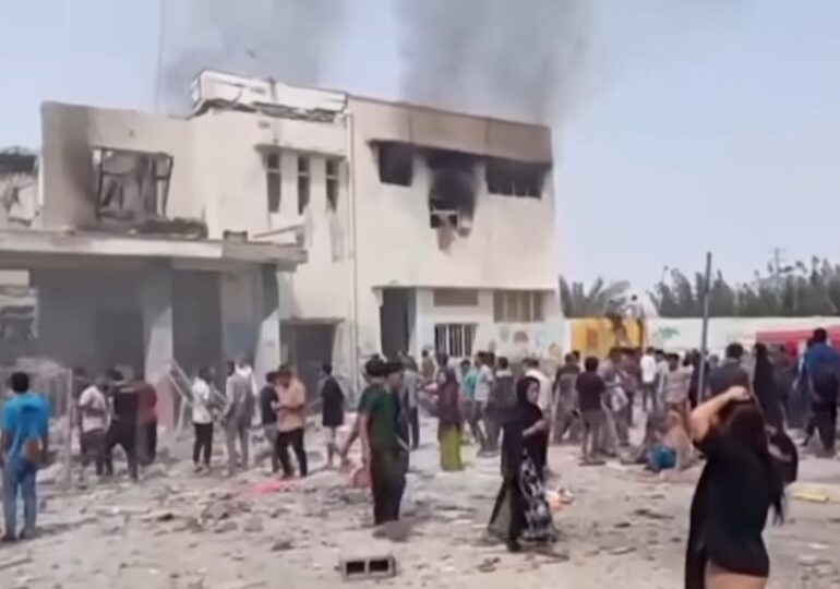
On February 28, an airstrike destroyed the Shajareh Tayyebeh primary school in Minab. The explosion killed over 100 people, most of them children.
President Donald Trump publicly claimed that Iran was responsible for the tragedy. "In my opinion, based on what I've seen, that was done by Iran... as you know, they are very imprecise with their munitions. They have no precision. It was done by Iran," Trump declared.

However, the President did not present any evidence to support the claim. Additionally, the US military has not confirmed this version, merely stating that they are "investigating" the incident.
Meanwhile, independent investigations based on OSINT (open-source intelligence) techniques are shaping a different reality.
The School Was Near an Iranian Military Base
Analysis of satellite images shows that the Shajareh Tayyebeh school was located near a complex of the Islamic Revolutionary Guard Corps (IRGC), which included a naval barracks and several auxiliary buildings.
In the past, the school building was part of the military complex. However, historical images show that for at least nine years, it had been separated from the base by a wall. Additionally, the building had clear visual indications that it functioned as an educational unit: colorful murals on the walls and small sports grounds.
There is no evidence that the school was used for military purposes at the time of the attack. However, its proximity to the IRGC complex could explain why the area was targeted in a military operation.
Post-Explosion Videos Indicate a Series of Strikes
Several video recordings that emerged immediately after the explosion have been verified by journalists and visual investigation experts. At least four videos show the same location – identified by the distinctive murals of the school.
In one of the videos, the camera captures the rubble of the destroyed building and then rotates towards dense smoke rising from the direction of the IRGC base.
This detail suggests that the bombing of the school was part of a series of strikes targeting the nearby military complex.

Satellite Images Show Multiple Destroyed Buildings
The first satellite images released on March 4 confirm the extent of the attack. They show the school completely destroyed and four other devastated buildings nearby, all located within the IRGC complex.
The data suggests that the strike on the school was collateral damage in a broader attack on Iranian military facilities.
A Tomahawk Missile Indicates an American Strike
On March 8, the Iranian agency Mehr published a video of a missile hitting a target in Minab. The recording was analyzed and geolocated by the investigation group Bellingcat, which identified the exact impact location.
According to experts, the missile in the images is a Tomahawk – a cruise missile used by the American military.
N.R. Jenzen-Jones, the director of Armament Research Services, a firm providing arms analysis expertise to governments and NGOs, explained that this type of missile very likely indicates an American strike. "Considering the belligerents involved, this indicates that it is an American strike, as Israel is not known to possess Tomahawk missiles," the expert stated.
He also dismissed the hypothesis that it could be an Iranian Soumar missile. "The munition in question is not clearly a Soumar missile: it has a distinctive external engine located towards the rear on the lower part," Jenzen-Jones asserted.
Pentagon Map Indicates Strikes in the Minab Area
Although the USA has not explicitly acknowledged hitting the school area, they confirmed conducting military operations in the region.
On March 4, during a Pentagon briefing, American officials presented a map of the strikes carried out in the "Epic Fury" operation.
Minab is not explicitly shown on the map, but one of the points marked as a USA/Israel strike area exactly corresponds to the region where the city is located.
However, there are no Iranian strikes indicated in that area on the map.
American officials stated that the initial US strikes focused on the southern coast of Iran – the region where Minab is located – while Israel mainly targeted the western part of the country.
Photos of the "Misfired Rocket" Are False
Following the bombardment, images circulated on social media allegedly showing an Iranian missile misfired. However, expert analysis indicates that the photos were taken approximately 1,600 kilometers away from Minab, in the northern city of Zanjan.
The images display snow-covered mountains – a landscape incompatible with the much warmer climate of Iran's southern coast.
Additionally, the visible panels in the photograph point to a dental cabinet geolocated in Zanjan.
The American President did not directly refer to these images and did not present any other evidence for the hypothesis of an Iranian missile misfire.
G.P.